Hello Everyone! When many of you will be reading this, Shadow Catcher and I will be celebrating the 4 year anniversary of this project. We set out together on November 11th, 2017 from our home base in Washington D.C. to Harpers Ferry, West Virginia. At the time, the plan was to spend a month in each of the 48 contiguous states, which, if done in one long stretch, would have put an end date right around now. I learned very quickly that a month isn’t very long when it comes to really getting to know a state and while I still try and move right along, six weeks seems like a more realistic timeframe. My dreams of financial success with this project have been all but a complete bust, so I have had to stop and go back to guiding to replenish my coffers. Thankfully, it’s a job I love and it’s fairly easy to put away money in a short time and keep going. And of course who could have predicted a global pandemic, which grounded us for 15 months at home? That time was a blessing as I got to spend it with my folks and watching young Mason every day on his journey from 2 to 3 years old. On the plus side, I’ve seen and done so much, learned more than I ever thought possible and met many truly wonderful people along the way. It’s been everything I hoped it would be and infinitely more and I’m grateful every day for this project, this journey, and all of you who have chosen to share in it. Like any journey, it’s had its ups and downs, but at the end of the day, I wouldn’t trade it for anything. As I wind up my time in Minnesota, my 16th of 48 states, that would leave me 1/3 of the way there. I don’t know if I’ll finish this project, but I’m definitely planning to keep going for the near future. Thank you all for coming along for the ride.
It’s been a very busy week blazing across the prairies of Southwest Minnesota. With daylight savings time ending and snow in the forecast, it is definitely time to start making an exit plan, but I didn’t want to miss out on a whole region. I’ve definitely driven more this week than I usually do and I’ve seen some pretty amazing places but it’s also been pretty fast and furious. That being said, I’ve driven past some fascinating things this week that either gave me pause or a good chuckle. When I drove through Brainerd again this week, I passed by the Warriors Early Childhood Learning Center. Their school team name is the Warriors, but to an outsider I thought this was pretty funny. I also drove past the towns of Nimrod, Sleepy Eye and Weetown – all of which made me smile. I saw a Sasquatch Reporting Station in Starbuck and a street called Oink Joint Rd. The Starbuck High School mascot is the Bucks, the Fergus Falls (county seat of Otter Tail County) is the Otters and of course in Pelican Rapids they went with… the Vikings! It was wonderful to see Amish buggies driving on the roads and tumbleweed tumbling down dusty city streets. It was a wonderful week of clear sunny days and I tried to make the most of it. Here’s what I got into:
When last I wrote I was headed clear across the state of Minnesota back to the western border. Along the way I stopped in the cute little town of Wadena to take some photos and have a wander. I ended up popping into the Little Round Still Distillery and talking with the nice folks there for a while. They gave me a lesson on Minnesota’s complicated liquor laws and it sounded like there is a lot to overcome when starting a brewery or distillery in the state. I ended up buying a 375ml bottle of their Gunflint whiskey which was quite good and the biggest bottle they could legally sell me. From Wadena, I headed on to the even smaller town of New York Mills to check out the Regional Cultural Center there. For a small town, this center is pretty well known and has a wonderful gallery and shop and hosts classes, workshops and events. There was a nice display of “wet felting” wall hangings by Kristen Anderson in the gallery when I was there which were beautiful and told an interesting story. There were also some other smaller pieces from previous exhibits upstairs. I was there for longer than I thought I would be but really enjoyed it. From there I headed on to Perham where I jumped on the Otter Trail Scenic Byway. This beautiful loop road took me through small towns and past some amazing prairie scenery as I made my way around Otter Tail County. I stopped in Pelican Rapids to take a photo of the world’s largest pelican and pulled into Phelps Mill right as the sun was setting to get some great photos of this historic mill now owned by the county. It was a great place to end my day and then I headed on to Fergus Falls for the night. I went downtown and found it pleasant but empty without a single bar or restaurant around. I really find it strange and sad when towns roll up their sidewalks after dark like that. I headed out of town and stopped for a quick beer at their brewery which was actually really tasty but way overpriced. I was sad that my only option for dinner at 8pm was Applebee’s which was on the low side of mediocre. For a town of 13,000 people I had expected a little more, but it was still a nice place to spend the night and it would redeem itself the following day.
The area surrounding massive Leech Lake, which now includes the town of Walker, Minnesota, has been visited by Native Americans for centuries. When European fur traders arrived, the Ojibwe occupied the area. The railroad came through in the late 19th century and a small lumber town was established and named after Thomas B. Walker, a lumber baron and one of the wealthiest men in America. Logging was king in those early days, but the beauty of Leech Lake soon started to attract tourism as well. Today, tourism is the main draw to the area but Walker also serves as the Cass County seat. Leech Lake is beautiful and I can certainly understand the draw. The town itself is also very attractive with a cute downtown area and some wonderful parks along the lakefront. While Walker was on one of my lists of photogenic towns to visit in the state, when I found out one of my friends grew up there I definitely knew I had to pass through. While she lives in Moab, Utah at the moment, her parents were kind enough to take me in for the night and show me a good time. When I went to take these photos the next morning, the sky was so blue I found it hard to leave. I hope you enjoy these photos of beautiful Walker, Minnesota, a pleasant town worth checking out on the shores of fabulous Leech Lake.
The Ojibwe referred to the body of water we now call Detroit Lake as “Gaiajawangag", meaning a lake with a crossing in a sandy place. The name “Detroit” was given to the area by a French missionary as “Detroit” means “straight” in French. The Old Red River Road came through Detroit in the early 1800s and was traveled by fur traders and Indians alike. When the Northern Pacific Railroad was pushing west through Minnesota, there was a small village on the lake known as Tylerville, named after Merwin Tyler whose small cabin on the lake also served as a hotel and post office. As the railroad came through, the city of Detroit was established in 1871 and in 1877 it became the county seat. The town provided ice and water to the railroad in the early days, but today’s economy relies heavily on tourism. The name was eventually changed from Detroit to Detroit Lakes in 1926 to avoid confusion with Michigan’s Detroit. I really enjoyed my stay in Detroit Lakes and found the downtown area to be quaint and historic while the lake itself was stunning - especially around sunset. I loved watching the trains cruise past the historic station and found beautiful art all over town. I hope you enjoy these photos from Detroit Lakes, Minnesota, a little town with a lot to offer.
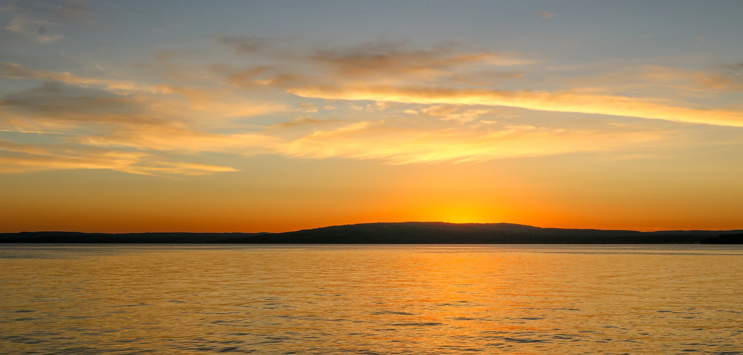
Thief River Falls gets its name from the falls at the confluence of the Red Lake River and the Thief River (which traces its name back to a conflict between the Ojibwe and Dakota people). These falls made navigation by boat impossible beyond this point, so a town was born here in 1887. Thief River Falls was originally a lumber town and then shifted to wheat farming, but it really took off when the Great Northern and Soo Line railroads came to town in the end of the 19th and beginning of the 20th centuries respectively. The rivers and railroads still power the local economy today and Thief River Falls is also the home of an Arctic Cat Snowmobiles plant. Thief River Falls has a population of around 8,600 people today and it really put on a show for me during my visit. The temperature hovered around 70 degrees under sunny skies and the sunset was absolutely spectacular. I hope you enjoy these photos from my visit to beautiful Thief River Falls, Minnesota.
According to their Chamber of Commerce, Bayfield is one of USA Today's Best Coastal Small Towns, Wisconsin's Smallest City, the Berry Capital of the State, and the Gateway to the Apostle Islands. That’s a lot for a place with a population of only around 500. the town was named in 1856 for Henry Bayfield, a British admiral and topographic engineer who explored the region in the 1820s.Lumber and fishing were the big industries in the early days and Bayfield also served as a port city. You can tell from some of the beautiful Victorian homes in town that at least a few people made their fortunes here. I found Bayfield to be a charming place with beautiful architecture and wonderful views out over the lake. It was my jumping-off point to both Madeline Island and Apostle Islands National Lakeshore. If you visit, be sure you try the local delicacy of whitefish livers which was one of the tastiest dishes I’ve had in a long time. I hope you enjoy these photos from this wonderful lakefront city.
Madeline Island is the largest of the Apostle Islands which sit just off the coast of Wisconsin’s Lake Superior shoreline. It is the only one of the Apostles which isn’t a part of Apostle Island National Lakeshore and the only one open to development. The permanent population of the island hovers around 300 but grows considerably during the summer months. The island is named after Madeline Cadotte, an Ojibwe woman and the daughter of Chief White Crane who married a white fur trader and lived on the island in the 19th century.
The island is important to the Ojibwe as a spiritual center and was also the home of Chief Buffalo, the man responsible for negotiating the Treaty of 1854 which helped create a permanent Reservation on the Lake Superior coast.
Madeline Island was a major fur trading post for many years and later industries included commercial fishing, logging and tourism. Both Father Marquette and Bishop Baraga (the “Snowshoe Priest”) visited the island and helped establish missions there.
I had a great visit to Madeline Island. The ferry only took about 20 minutes to make the crossing and I brought my van with me and stayed at wonderful Big Bay State Park on the far side of the island. The ferry docks at La Pointe, the island’s only town which has several restaurants, bars and shops. It’s also where I found Tom’s Burned Down Cafe, one of the coolest bars I went to in the state. I enjoyed hiking in the state park and a long drive around the island on a very well maintained dirt road. I was sorry that the museum was closed when I was there, but I’m sure it had some interesting artifacts in it. Sunset over Lake Superior looking back at the mainland was magical. I hope you enjoy these photos from my time on beautiful Madeline Island.
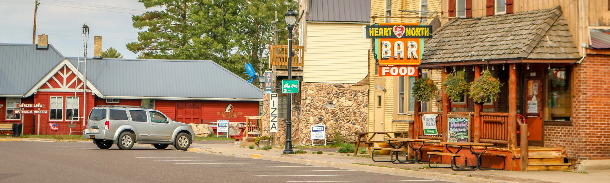
Mercer is a small community of under 2,000 people situated along Highway 51 in Iron County, Wisconsin. The area has one of the highest concentrations of loons in the country and Mercer has designated itself The Loon Capital of the World. The town placed a massive 16 foot loon at its Chamber of Commerce named Clair d’ Loon. Every year in August, Mercer celebrates Loon Day which includes a loon calling contest. I thought it was a great little town with some fun shops and a cute Northwoods-style downtown area. It seemed like a lot of the businesses in town were for sale, so maybe this would be a great opportunity for someone looking to move to the area. I wasn’t in Mercer long, but it definitely charmed me and I wanted to share these pictures with you from The Loon Capital of the World.
The Driftless Region of Wisconsin is the area below the furthest advance of the glaciers during the last Ice Age and covers most of the southwest portion of the state.. It is home to wonderful, ancient sandstone formations, beautiful parks and great little towns. This area is definitely hillier than much of the rest of the state and ends (at least as far as Wisconsin is concerned) at the Mississippi River on its western border. I had a great time exploring the Driftless, boating through the Wisconsin Dells, walking the State Park trails, driving the Great River Road and exploring the towns I found along the way. I encountered many different European-American traditions along the way including two of Wisconsin’s most famous: beer and cheese. I visited Wisconsin’s first Capital at Belmont, it’s biggest tourist attraction at House on the Rock and some of the state’s mining history at Mineral Point The Driftless is a sprawling region with a diverse culture and a fascinating history. I hope you enjoy these photos from Wisconsin’s Driftless Region, a unique place which I really enjoyed visiting.
Hello Everyone! It’s been a little quieter out here on the road this week than the last few weeks. I’ve tried to slow down a little and get some fishing in while I’m here and the warm weather is too. Unfortunately, I’ve also managed to catch a cold this week which has only slowed me down further. I’ve caught this cold even with all the hand-washing and masking and being careful which just goes to show how easy it is to pass things along. I’ll be laying low for a couple of days, hydrating and getting some sleep and hopefully it’ll pass on through sooner rather than later. This week brought me from the middle of Wisconsin’s section of the Great River Road to the heart of the Northwoods, and it’s been a really wonderful week which I can’t wait to tell you about.
When I left you last week, I was in La Crosse which really is quite a nice little city. There are lots of old buildings and corner bars and with a reasonable sized student population it felt very vibrant and alive. Last Wednesday night I went for a cruise on the La Crosse Princess, a sternwheel paddleboat that does several different tours on the Mississippi River. I went on a short 90 minute beer and pizza cruise which was definitely a bargain at $21. It was nice to be out on the river, and that length of time was just about perfect for my attention span. The weather was perfect and I really enjoyed it. After the cruise I went and saw some live music at Big Al’s downtown which was great and sat with a wonderful older lady who was very into the live-music scene. It was very kind of her to ask me to join her. We had a nice chat and enjoyed some good music and she invited me out the following night to a different venue.
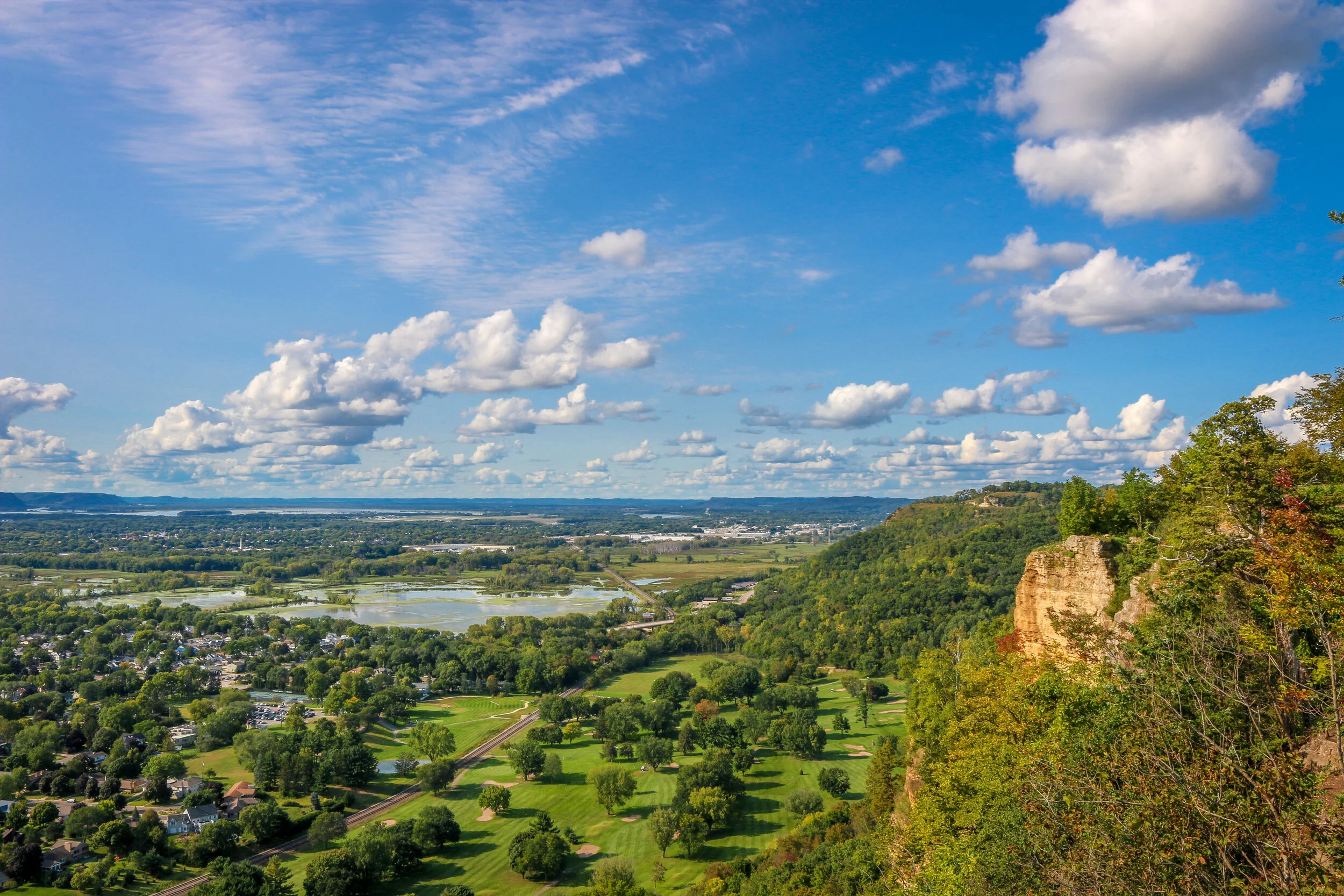
Thursday I spent a good chunk of time in the library, trying to get a jump on some work for this week. In the afternoon I drove up Grandad’s Bluff, La Crosse’s most well-known geologic feature. The road took me right to the top for wonderful views out over the city and the Mississippi River. It was cool and quiet up there and I stayed up on top for quite some time. Later that evening I went for a stroll along the Mississippi and then to a wonderful night of live music at the amphitheater right there on the river. It’s getting a little cooler out and it was nice to just sit outside and have a beer and enjoy the music. The band was good and I stayed right up until the end. Afterwards I joined my friend from the previous evening at the old train station for a really good grandfather-grandson duo and met her boyfriend and granddaughter. When the band finished up, I took one last stroll around town and then called it a night.
Friday morning I was up and off and headed north along the Great River Road. I stopped in the small and charming river towns of Trampealeau and Alma for a while and found a nice apple orchard along the way to pick up some fresh apples which are just coming into season up here. Then I headed on to Nelson for lunch under the Twin Bluffs and an ice cream at their wonderful creamery. From there, I moved on to Pepin which is best known as the birthplace of Laura Ingalls Wilder.
Washington Island is just a quick 30 minute ferry ride from the tip of the Door County Peninsula, but you have to cross Death’s Door to get there. The story I heard was that Potawatomie and Winnebago (now referred to as Ho-Chunk) Indians occupied opposite sides of the passage. One day they both sent war parties in boats to attack the other side but a storm came up and killed all of the warriors who set out that day. When they later recalled this story to French trappers, the passage was named Porte des Mortes or Door of Death. This is where Door County gets its name.
I had a wonderful visit to Washington Island and crossed Death’s Door twice without incident. The island is a pretty good sized rock and traces much of its European heritage back to Scandinavia. I read that Washington Island has the highest concentration of Icelandic-Americans in the country. I learned about some of the island’s cultural history at the Jacobson Museum and some of its fishing and boating history at the Maritime Museum. At Nelson’s Hall the bartender told me that the proprietor got his pharmacy license during Prohibition and served up straight 90-Proof Angostura Bitters to his patrons as “stomach medicine”. Now you too can join the “Bitters Club” by doing a full shot of it yourself (which obviously I did). Nelson’s is the top seller of Angostura Bitters in the country. Next door at K.K. Fiske’s you can enjoy a fresh grilled “Lawyer” or Burbot fish, although sadly they didn’t have any there for me during my visit. The Stavkirke is a beautiful recreation of a traditional Norwegian Stave Church and is really quite breathtaking to see and definitely one of the top highlights on the island. There are other cool Scandinavian buildings around as well and many people proclaim their heritage with that country’s flag on their mailbox. I spent a lot of time at Schoolhouse Beach which is a beautiful protected harbor on the north side of the island which boasts a beach made up of perfectly smooth stones. If you’ve followed me long enough, you know I have a special place in my heart for islands and will explore them whenever the opportunity presents itself. I really enjoyed Washington Island, especially since I could bring my van out there with me. I only wish it had been sunnier while I was there so you could really see how beautiful it was, but the weather is what it is when I am where I am, and it was pretty cloudy during my stay on the island. I hope you enjoy these photos from beautiful Washington Island because I had to cross Death’s Door to get them.
The Keweenaw Peninsula juts north from Michigan’s Upper Peninsula far out into Lake Superior. The word “Keweenaw” comes from an old Ojibwa word meaning “a place where portage is made”. This area is home to one of the richest copper deposits in the world and has been mined for thousands of years. After Michigan became a state in 1837, prospectors started making their way into the Keweenaw and copper claims and mines were quickly established. These mines were often in operation until World War II. Around these mines, communities grew which were often settled by immigrants eager to build a life in the new world. Mining was dangerous work, but the promise of a decent wage was enough to lure people to this isolated northern region. When the price of copper dropped and the mining process was no longer profitable, whole communities packed up and moved elsewhere and once-bustling towns were quickly reclaimed by the forest. Some towns remain today, but many are struggling and reliant on tourism. I loved this region and spent a little over a week exploring its history and towns. I toured the Quincy Mine and enjoyed wandering around Houghton, Hancock, Calumet, Eagle River and Copper Harbor. I included a few photos from nearby Marquette as well since it traces its roots to the same time period. The whole region is now a part of Keweenaw National Historical Park and Keweenaw National Heritage Area and you can find the Visitors Center in downtown Calumet. I hope you enjoy these photos from the beautiful Keweenaw Peninsula, Michigan’s Copper Country.
The Ojibwa Indians called Isle Royale “Minong” meaning “a good place to be” and they certainly hit the nail on the head with that one. Isle Royale National Park consists of Isle Royale itself and over 400 smaller islands making up an archipelago in the middle of Lake Superior. Isle Royale is the largest natural island on Lake Superior and the second largest in the Great Lakes at 45 miles long and 9 miles wide. Some of Michigan’s earliest copper mines were established on Isle Royale in the 1840s, continuing the Ojibwa copper-mining tradition which stretched back hundreds of years. Commercial fishing operations also ran off of Isle Royale for many years, but it was the island’s beauty and ability to attract tourism which would create its lasting industry. Isle Royale National Park was established in 1940 and it was made a part of the UNESCO International Biosphere Reserve in 1980.
I had a wonderful 4 day/3 night visit to Isle Royale in the beginning of August. The island is only accessible by boat or plane, with ferries originating out of Houghton and Copper Harbor in Michigan and Grand Portage in Minnesota. I chose the Isle Royale Queen IV out of Copper Harbor which dropped me off in Rock Harbor on the island’s northeast side in about three and a half hours. After getting my backcountry permit from the ranger there, I headed off into the wilderness for the next three nights, staying at Daisy Farm, Lynn Cove and Three Mile campgrounds. I hiked about 25 miles during my time on Isle Royale and really found the island to be a beautiful place to be. After hiking all day, an afternoon dip in Lake Superior always felt great. I saw 9 moose during my visit and also a handful of beavers along with plenty of birds and toads. I really cherished my time on Isle Royale and hope you enjoy these photos from America’s least visited National Park.